Mt. Natazhat's Northeast Ridge
Paul, I don't feel so good. I think I'm gonna be sick." The cloudy mountain weather was giving our DeHavilland Beaver a rough ride as we flew over the Nizina River and into the Wrangell Mountains. Frantically, I stripped the zip-lock baggie from our hand-held aviation radio. Just in time, I positioned the baggie in place as a final wave of nausea surged through my body. Last night's dinner from Chitina's "Burgers and Brew" wasn't quite as I remembered it.
The Wrangell and Saint Elias Mountains of southeast Alaska are two of the most rugged and remote mountain ranges in North America. They lie within America's largest national park, the 13 million acre Wrangell - Saint Elias National Park. Combined with Canada's adjacent Kluane National Park, over 18 million acres of unspoiled mountain wilderness present a lifetime of climbing objectives for both the expedition and alpine mountaineer. Sixteen of Alaska's twenty tallest mountains lie within the Park boundary. In addition, the Saint Elias Mountains are the highest coastal range in the world and have the largest concentration of peaks over 14,500 feet in North America.
Most first-time climbers to the area will attempt one of the Park's larger peaks such as Mounts Saint Elias, Blackburn, Sanford or Bona. These, and some of the ten other peaks over 14,000 feet may see several attempts each summer. However, if solitude is more important than altitude, one can simply choose a smaller peak and enjoy a true wilderness experience. For those interested in the unknown, countless summits below 10,000 feet have yet to see a first ascent. Or for those with loftier goals, moderate to difficult unclimbed lines still remain on the larger peaks, as well.
Our goal was Mt. Natazhat (13,435 feet, 4,095m). First climbed on June 18, 1913, the peak had survived eighty-three years before our second ascent in April 1996. Canadian surveyor Frederick Lambart, of the joint US -Canada International Boundary Survey, led the first ascent up the gentle southern slopes from the Klutlan Glacier. The 1915 Canadian Alpine Journal, pages 1-10, chronicles their first ascent. From 1907-1913, the Boundary Survey mapped and surveyed the 650 mile Alaska - Canada border from the Arctic Ocean to the Gulf of Alaska. When they began their project, the border existed on paper only, yet it traversed through some of the most rugged wilderness remaining in North America. As the years passed, the border was cleared, surveyed and then marked with permanent monuments every three miles. The exception to this was the heavily glaciated terrain immediately south of Mt. Natazhat and north of Mt. Saint Elias. This uninhabitable 85 mile stretch of mountains and glaciers allowed for only three locations suitable for their permanent boundary markers.
During his successful 1913 ascent of Mt. Natazhat, Lambart was hoping to link the north and south edges of this "no-man's land" using survey equipment he carried to the summit. Unfortunately, poor weather prevented this, and they had to console themselves with the first ascent of Mt. Natazhat. Two miles east of Mt. Natazhat lay Mt. Riggs (11,783'). This peak was named in honor of Lambart's American counterpart, Thomas Riggs, Jr., Chief of the US section of the Boundary Survey from 1907-1913. An engineer by education, he took great pride in having created "the straightest of the world's surveyed lines." Riggs, an honorary member of the American Alpine Club, organized the first recorded attempt to climb Mt. Natazhat in 1909 to aid his surveying efforts. However, in August of that year, his men were turned back from their southern attempt by an early fall storm. Four years later, Lambart's party succeeded in making the prized first ascent. Riggs went on to become Governor of the Alaska Territory from 1918-1921. After its 1913 ascent, Mt. Natazhat's remote location and relatively small stature likely prevented future attempts for the next thirty-eight years.
During the summer of 1951, a Stanford University trio spent five weeks on the 55 mile long Klutlan Glacier making first ascents of Mounts Bear, Churchill and Jordan, and an early ascent of Mt. Bona. Their southern attempt on Mt. Natazhat was thwarted by the loss of their gear sled into a Klutlan Glacier crevasse. The 1952 American Alpine Journal, pages 240-249, summarizes their 53 day wilderness expedition. After this 1951 attempt, Natazhat likely did not see any suitors until 1995, when Anchorage climbers Harry Hunt and Danny Kost were the first to attempt its spectacular Northeast Ridge. Over the years, Danny has spent hundreds of hours researching unclimbed peaks and routes in the Wrangell and Saint Elias Mountains. He knew that Natazhat's Northeast Ridge was a gem. When Harry visited Boston in 1994, Danny suggested that he meet with Bradford Washburn, of the Boston Museum of Science, to discuss the feasibility of this route. Over the last 60 years, Washburn has photographed and cataloged every major mountain in Alaska. Washburn's extensive library of black and white prints contains a wealth of route information on Alaskan peaks. After Harry returned to Anchorage, he and Danny agreed to try the Northeast Ridge the following summer. They made it to almost 10,000 feet before illness forced them to retreat. Undaunted, they made plans to return the following Spring. Unfortunately, work commitments prevented Danny from rejoining Harry. Instead, Harry recruited fellow Anchorage climbers Paul Barry, Dave Lucey and me to join him for a second attempt at this virgin line in April 1996.
Chitina (pop. 75) is located at the western boundary of the Park, and many trips into the Wrangell - Saint Elias Mountains begin there. Paul Claus of Ultima Thule Outfitters has over 18,000 hours of mountain flying time, and is the premier mountain bush pilot of the region. Not long after sunrise on April 6, Claus met the four of us at Chitina's gravel airstrip. Two hours later, we were standing on a glacier amidst a jumble of packs and duffel bags as the distinctive drone of Claus' orange Beaver disappeared behind a ridge. I, for one, was glad to return to solid ground. For the next ten days, the only reminder of the outside world was an occasional jet airliner cruising overhead at 35,000 feet.
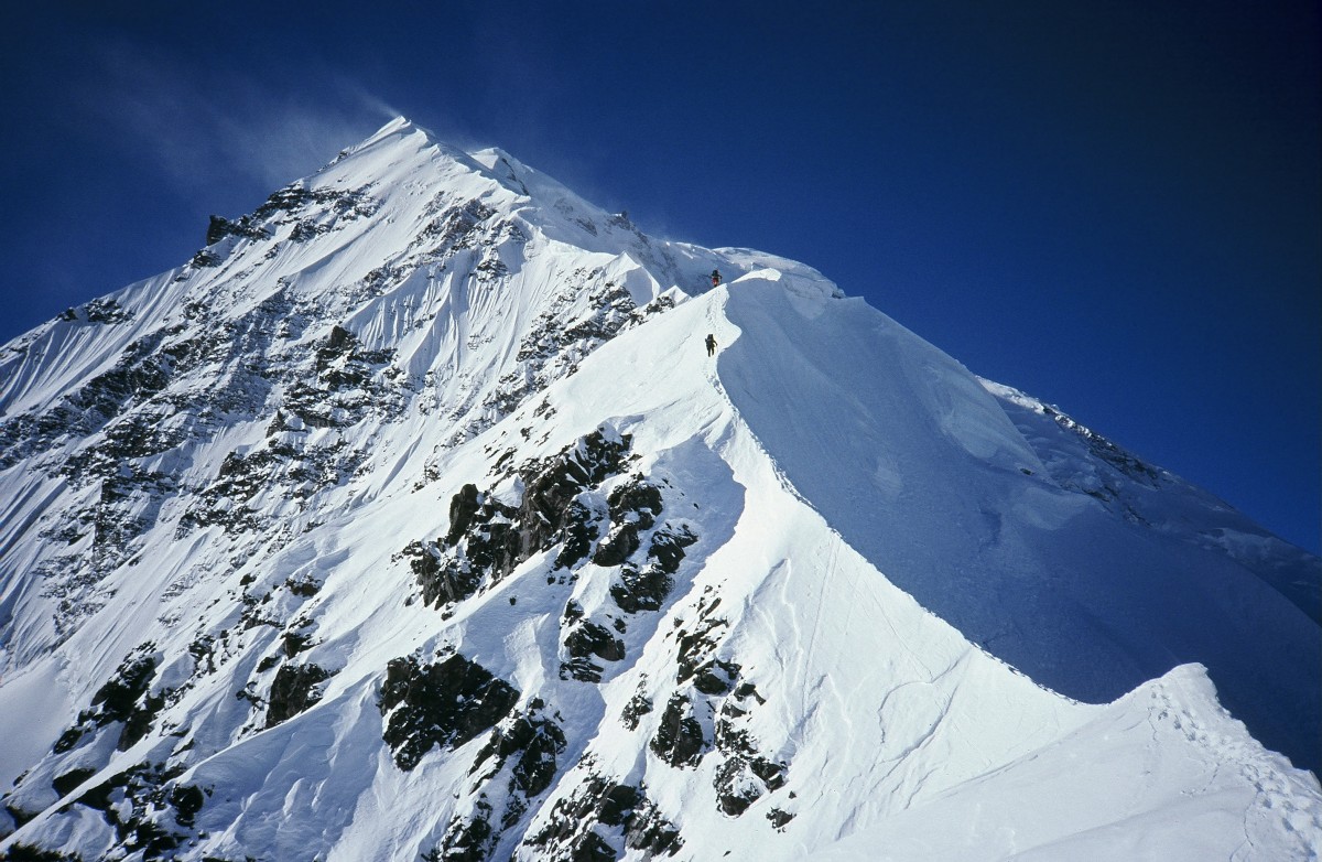
On the flight in, we finally caught a glimpse through the clouds of our objective. Natazhat's Northeast Ridge presents a striking knife-edge rising over 7,000 feet from the gentle tundra below. Washburn's black and white print "E. Face of Mt. Natazhat - #554" published in the 1944 AAJ (page 199) highlights this classic snow and ice route in its entirety. Given this photo, it is surprising that Harry and Danny were the first to attempt this impressive line eleven months earlier. Interestingly, this interior region of the Wrangell Mountains receives substantially less snow than the infamous coastal Saint Elias Range, only eighty miles to our south. As a result, and certainly to our benefit, our route would not be plagued by cornices or deep snow. Our base camp was situated on a small pocket glacier at 7,600 feet near the base of the Northeast Ridge.
Between us and the summit lay four and a half miles of narrow and, at times, knife-edged ridge. In addition, points 9150 and 9564 had to be climbed before the final 4,000 foot summit ridge could be attempted. This final one and a half miles was still unknown terrain, as Harry and Danny had turned around just below there. Climbing alpine style, Harry felt that the route could be completed in as little as six days, placing three camps along the ridge. The unknown technical terrain above 10,000 feet encouraged us to carry as little weight as possible. We did resign ourselves, though, to bring 500 feet of fixed line in case the going got tough. "OK. Six days of food and eight of fuel, is that right?" With everyone in agreement, e loaded our packs and crossed our fingers, hoping the next week would be kind to us. Just before we left, I began having second thoughts. I couldn't bring myself to knowingly begin a climb in unsettled weather without any food reserves, so I tossed in a couple extra food bags and gas canisters. The extra weight was worth the peace of mind I now had.
Within two hours of Claus' departure, we started up the route. An hour of hiking along a snow free ridge provided a good warm-up before we roped up to tackle point 9150. Although not technically difficult, an occasional crevasse warranted this precaution. Relatively straight-forward ridge walking found us up and over point 9150 by early afternoon. An hour later we had traversed some rock gendarmes on their left, and had arrived at our first campsite by 5:00 PM. We placed Camp 1 at 8,800 feet in the saddle between points 9150 and 9564. \"Hey Paul... David... Are you guys awake in there?\" Harry shouted from the other tent. It was 1:00 AM, the winds were gusting to about 40 mph and sleeping was difficult, even with earplugs. Last evening, we had neglected to build snow walls around our small bivi tents. Now we were paying for it. Harry and Paul drew the short straws and spent a couple of hours reinforcing our camp by moonlight. Dave and I knew we were on deck for the next midnight storm shift, but to our delight we were never called upon for the duration of the trip! Our second day on the route, Easter Sunday, presented a bit more exposure and technical difficulty. Our ski poles were replaced by two ice axes each. We would now begin climbing with either running or pitched belays protecting the steeper sections. Our gear racks consisted of three pickets, six ice screws and ten runners per rope team. In retrospect, this was adequate, although two fewer screws would have sufficed due to the snowy conditions we encountered. \r\n\r\n
Through unsettled weather, we climbed over point 9564. A few crevasses required some fancy footwork, and a couple of small snow steps necessitated pickets for protection. The descent to the col on the south side of point 9564 was straightforward with the exception of a few crevasses. Just beyond the col, we reached our site for Camp 2 at 9,300 feet after five hours of climbing. With point 9564 behind us, the following afternoon would find us on virgin terrain and what was to be the crux of the route. An hour beyond our Camp 2 we could see a prominent crevasse splitting the ridge. We were looking forward to reaching this milestone, as this is where Harry and Danny had turned around a year earlier. While Harry and I set up Camp 2, Dave and Paul explored a route to this crevasse to aid our climb the following morning. \r\n\r\n
\"It\'s gonna be a lot of work. It looks pretty hairball,\" Paul commented after he and Dave returned from their reconnaissance two hours later. I wasn\'t really sure what to expect, but I knew that our third day would prove to be exciting. \"How\'s it look outside, Harry?\" I asked. \"Great. Sunny and clear. If you guys would get out of bed, you could see for yourselves!\" Our third morning found the weather finally changing for the better. Nighttime lows still hovered around minus 10 F, but the sunshine and calm winds would make for comfortable climbing during the day. \r\n\r\n
As was becoming our habit, we didn\'t break camp until 11:00 AM. An hour later, we reached the massive crevasse, beyond which no one had ever climbed. From this point on, we would not benefit from Harry and Danny\'s prior attempt on the route. Upon reaching the crevasse, we found that it ran perpendicular to the ridge crest, preventing all forward travel. The only safe passage was to down-climb left off the ridge proper along the edge of the crevasse for eighty feet, to a point where a snow bridge spanned the gap. Once across this bridge, an eighty foot climb back up along the opposite edge of the crevasse rejoined our route. For the next five hours, every step was hard earned. We eased our way up the narrow crest, using both running belays and pitched belays as we climbed. One or two ice screws or pickets on each pitch provided relatively secure anchors for this airy climbing. \r\nDraping our fifty meter ropes on alternating sides of the knife edge, where possible, also acted as running belay anchors. Frequently, we would find ourselves traversing on front points on one side of the ridge with our arms draped over the crest, plunging the shafts of our axes into the opposite side as a self belay. The hard snow conditions we experienced made for secure, albeit exposed, climbing. Surprisingly, every time we came to an intimidating section, the solid snow or ice made it easier than expected. Unconsolidated powder would have certainly slowed us down. \r\n\r\n
Our most entertaining maneuver of the day was probably the au-cheval position Dave employed while leading across a particularly narrow spot. We were all thankful that barely a breath of wind was present on this fine afternoon. \"David, I\'m sick of carrying this fixed line!\" Paul shouted to me from the other end of our rope. It was becoming apparent that our 500 feet of fixed line was nothing more than an anchor slowing us down. Agreeing that we wouldn\'t need them, Dave and Paul each chopped a ledge and cached our two bundles of nylon joy. Two days later we would retrieve them on our descent. After nearly six hours and roughly ten pitches of tricky climbing, our nerves were ready to call it a day. Unfortunately, there was no sign of any suitable, or even unsuitable, campsite. Two pitches above us, the ridge steepened considerably for a pitch, then appeared to blend into gentler snow slopes where we might be able to dig in. This final pitch was certainly the crux of the day. The knife-edge angled up at 60 degrees, and at the same time dropped off to either side at an even steeper angle. The exposure was tremendous! \r\n\r\n
As Harry led through this final steep and narrow pitch, he disappeared over the lip on top. A couple minutes later his head popped back into sight. \"Looks good! We should be able to dig in up here!\" We all breathed a sigh of relief. Camp 3 turned out to be better than we could have ever expected. Harry had discovered a ready-made crevasse camp, located at 10,600 feet along the extreme left edge of the ridge. After a bit of probing and shoveling, our bomb proof site was ready for habitation. With three walls and a roof, it was just big enough for two Bibler tents. Instead of a fourth wall, our high camp had a tremendous drop out over the massive 5,(X)() foot east face of Mt. Natazhat. This was certainly no spot for sleepwalking! We were beginning to realize that campsites on this route were very much dictated by the terrain. Fortunately, we had fallen in sync with the mountain, and were not troubled by the distinct lack of plentiful campsites. \r\n\r\n
\"OK guys, time to get up!\" Harry\'s voice reeled us all in from our dreams of sandy beaches and sun-bronzed women. Emerging from our ice encrusted down cocoons was always the worst part of the day. Any movement in our cramped quarters would knock loose a shower of ice feathers perched precariously from the interior tent walls, hanging like bats inside a cave. \"Ouch! I can\'t believe I just did that!\" The smell of singed flesh permeated our tent. Over the past two days, lulls in our concentration while cooking with our powerful hanging butane/ propane stove had resulted in singed gloves, hats and jackets. On this morning, we added Paul\'s forehead to our list of casualties. \r\n\r\n
We left for the summit at 10:15 AM, April 9, under sunny and calm skies. It looked like a great summit day! Although we had hoped that our high camp would open the way to 2,700 feet of easier climbing to the summit, it turned out that a mistake on summit day would prove equally as dire as on the rest of the route. Right out of high camp, we were greeted by three pitches of fifty degree snow and ice. \r\n\r\nOur lack of freshly brewed coffee was more than compensated for by the adrenaline of summit morning. Again, we protected ourselves through this initial slope with running belays using ice screws and snow pickets. Above this, two hours of easier terrain interspersed with steeper steps helped us gain some quick altitude. By 1:00 PM, we were traversing yet another improbable looking knife-edge at 11,800 feet. \r\n\r\n\"Paul, why don\'t you come on back, and we\'ll drop down and try to traverse below it!\" I shouted. After placing a picket, an ice screw and traversing along a rotten rock ledge, he responded, \'\'I\'m almost to easier ground, and I certainly don\'t want to come back now!\" We were encouraged that he was nearly across, although we weren\'t particularly looking forward to following his traverse. Paul ducked around a comer and disappeared from sight. We kept expecting to see him launching into space after each salvo of rocks that he knocked loose. As I paid out the last of the rope, it came taut and Paul and I began climbing together. Paul had already cleared off most of the rotten snow, ice and rock, so the remaining three of us had an easier time following his lead. A few hundred feet later, a final tip-toe across a rotten rocky crest led to easier snow slopes above. A yellow spot in the snow greeted each of us as soon as we reached these easier slopes. \"Paul, it looks like you just barely made it across before peeing your pants!\" was the comment from each of us upon reaching this point. After a quick lunch break at 12,(X)() feet, we began the final 1,300 foot climb to the summit ridge. \r\n\r\n
Straightforward thirty to fifty degree neve led us to the unclimbed lower eastern summit by 3:45 PM. \"Oh, no! What a bummer!\" I said to Paul upon joining him on the eastern summit. Our hopes of continuing on to the western summit, a mere fifty feet higher and a quarter mile distant, burst as soon as we looked along our intended route. It was not a welcome sight. What we hoped would be a simple trot along the summit ridge appeared almost impassable. At least three huge gaping crevasses seemed to bar the way. Checking our watches, we found it had taken us five-and-a-half hours to reach this point. With only five hours of daylight remaining, we were beginning to think it might be prudent to turn around now. \r\n\r\n\"Well, we did climb the route,\" Harry rationalized. Dave and I nodded, resigning ourselves to not making the true summit. We were all disappointed, but not enough to continue on and risk down-climbing back to high camp in the dark. \"Come on guys, let\'s try a bit further. We can spare an hour or so, and still get back before dark.\" Paul was the lone dissenter urging us to push on. According to the map, it was only a quarter mile to the other peak, even though it looked much further. \"OK, half an hour it is,\" we all agreed. \"And then we tum back for home.\'\' \r\n\r\n
Following Paul\'s lead, we soon found a route invisible from our last vantage point that turned out to be a cruise. \"Welcome to the top of Mt. Nat.a.zhi.tt!\'\' was Paul\'s greeting as I joined him twenty-five minutes later on the higher western summit. Sunn)\' .md aiJ.m blue skies afforded us dear views all the way from Mts. Logan and Saint Elias to Mts. Blackburn and SMford,. a. toW distance of nearly 200 miles. All four of us Celt that it was perhaps the best weather we had ever experienced on an Alaskan summit. Tlwre wtt,S no imp(\'nding doom of a.n apprO<\'tdti.ng storm, and no wind knocking us from our feet. It was a true joy to <:elebrate I.his afternoon among ou.r group of friends, and especially Paul. with whom I have sMred mMy other Alaskan sunurulS. \'\'You know, l think the other peak is higher,\" Paul offered. Both his .Utimeter and our vLSuaJ judgr:nent indk.ated that the \"lower\" eastern summit w4.s slightly taller than the \r\n\"higher\"\' west.em summit where we now stood. \r\nWas Lhe map wrong? Had we just come from the utllcr SU.JruJul? Did we just go out of our w4y to climb the .shorter summit? The 1913 first ascent party reachcd lltis \"higher\"\' wcstem swrunit in a white out, \r\nand did not continue to the eas-tem summit. As such, we wcre the only ones lo have 1.wcr be-en &blc to make this height compariso11. That is unfortunate, as it would have been i.nteresU.ng to know Lhei.r observations on this possible discrepancy with the USCS map. \"OK, Pau.1. Slow and steady on the way down.\" All too soon, fifteen minutes had passed and we begal\\ our des<:cnt \'9.l 4:30 PM. four hour later, as the last rays of Light began to fade behind Mt. Blackbun,, the four of u.s n>.ached the safety of ou.r high camp. \r\nC.u-cful down-climbing Md iU\'I occasiol\\il.l belay allowed us to make the descel\\t without leaving any gear i.n pla<:c. Although our trip was far from O\\tCI\', we knew that t\',;,•o more days of good wealher and more CAT